Share This

Showing posts with label Slope and Hill management. Show all posts

Monday, January 29, 2018

Make environment our 2018 priority

Our Environment is Our Life - YouTube

THE year has barely started, and already we have so many reports of weather and climate-related events.

Heavy wind, snow storms and below-freezing temperatures paralysed cities in the United States’ East Coast. New York’s John F. Kennedy International Airport was in chaos with hundreds of flights suspended.

Yet, just weeks previously, big fires linked to a heat wave were sweeping through parts of California on the West Coast, burning 112.000ha of forest and threatening lives and homes.

Colder weather in one place and hotter temperatures in another are signs of global climate change, which can also cause heavier rainfall and drought in different regions.

While it is difficult to pin down any particular incident as a direct result of climate change, it is recognised scientifically that climate change generally exacerbates extreme weather events and may cause some of them.

We can expect the weather, and more broadly the environment, to figure prominently this year.

The alarm bells sounded long ago on the environmental crisis. But it is not easy to achieve a continuous high level of concern among political leaders.

After a calamity and public outrage, there are pledges to correct the situation. However, the interest fades after a while, and not much action is taken, until the next disaster happens.

In Malaysia, people are now looking at the sky constantly to anticipate whether it is going to rain.

Heavy rainfall has been causing floods in Kelantan, Terengganu, Pahang, Johor, Negri Sembilan, Kedah, Selangor, Sabah and Sarawak.

In Penang, severe state-wide flash floods seem to be occurring every few months, with localised flooding in several areas in between. The mud brought down from eroded hill-slopes into overflowing rivers and then into houses, makes floods an even worse nightmare for those affected.

For some unlucky ones, hardly have their houses and furniture been cleaned than they are under one metre of water again through a new flood.

Heavier rain and more floods is the new normal in Malaysia. There has been an increase in rainfall for most parts of the country in 2000-2009 compared to 1970-1999, with the major increase in 2005-2009, according to a 2012 paper by Yap Kok Seng, then the head of the Malaysian Meteorological Depart­ment (MMD), and his colleagues.

The global temperature increase has led to changes in weather including major wind patterns, amount and intensity of precipitation, and increased frequency of severe storms and weather extremes, according to the paper, Malaysia Climate Change Scenarios.

In Malaysia since the 1980s, there had been increasing number of days of extreme rainfall events, extreme wind events and annual thunderstorm days, added the paper.

Unfortunately the situation will worsen. A study published on Jan 10, whose authors are affiliated with Germany’s Potsdam Institute for Climate Impact Research, predicted that millions more people will be affected by river flooding as global warming increases severe rainfall in the next 20 years.

In Asia, the most affected region, people at risk from floods will rise to 156 million from the present 70 million in the next 20 years.

Global warming increases the risk of flooding because rain during an extreme downpour “increases exponentially” as temperatures rise, the institute’s Anders Levermann told Reuters.

“We have to adapt to global warming. Doing nothing will be dangerous,” he said.

Countries will have to act urgently and make major investments in flood protection to boost their flood defences, according to the report.

This advice surely applies to Malaysia as one of the countries already being affected by heavier rainfall and extensive river flooding.

Flood mitigation measures must be increased, including de-silting, widening and deepening rivers, improving urban drainage, strengthening river banks, redirecting water flows, constructing tidal gates, and pumping excess water into ponds.

Even more important is flood prevention. A main cause of the floods is deforestation, leading to the loss of the forests’ valuable roles in soil and water retention and climate regulation.

It is really short-sighted and irrational to damage and destroy forests, especially forest reserves and water catchment areas.

Exposed soils are swept by rain into rivers, clogging up streams and drains with mud and causing floods downstream in the towns and villages, while also depriving us of much-needed water supply.

There is a great deal of public concern over recent developments that threaten forests and hill lands in the country.

These include the de-gazetting of the Ulu Muda water catchment area in Kedah; the de-gazetting of hill lands in Penang that previously were protected under the Land Conservation Act and which are now being “developed” with the aid of higher permitted density ratio; the conversion of 4,515ha forest reserve to cultivate oil palm plantations in Terengganu (being opposed by WWF-Malaysia); and protests over the imminent loss of a forested park in Taman Rimba Kiara in Kuala Lumpur to make way for housing.

Federal, state and local governments should give priority to environmental rehabilitation of damaged forests and hills, prevent damage to the coastal ecosystem including mangroves, and take comprehensive flood prevention and mitigation measures.

They should stop approving environmentally harmful projects in ecologically sensitive areas.

They must make major financial allocations to protect and rehabilitate the environment, and implement finance measures to prevent and manage the floods.

As so many scientists are warning, and as more and more local communities and citizen groups are demanding, the time to act on the environment is now. Let us hope that in 2018 these calls will be heeded.

Global trends by Martin Khor

Martin Khor is executive director of the South Centre. The views expressed here are entirely his own.

Related posts:

Behind BJ Cove houses at Lintang Bukit Jambul 1 is an IJM Trehaus Project.  Approximate Coordinates : 5°20'38.47"N,100°16'...
https://youtu.be/ooyXvqmxbvw GEORGE TOWN: Some 20 houses located on a slope in Hong Seng Estate in Mount Erskine were flooded due
Wet, wet woes: (Above) Bukit Jambul is flooded once again after an evening downpour. Firemen installing a pump to draw floodwater...
Council should not bow to development or political pressure, says city councilor, Khoo ‘Politicians should be ‘wakil rakyat’ and n...

Seeking solutions: Penang Forum member and soil expert Dr Kam Suan Pheng giving her views during the dialogue session themed ‘Penang Fl...

(From left) Dr Kam will deliver a talk on ‘Understanding the Causes of Floods and Seeking Solutions. State assemblymen expressing inter...
https://youtu.be/4qaOB1n5tgA GEORGE TOWN: The Penang Island City Council has lodged a police report against the consultant of the aff...

Speaking out: Penang Forum members protesting outside the CAP office in George Town. Don’t just make it about worker safety issues ..

https://youtu.be/QB45Q2_mOG0 Suspicious activity: A photo taken from Penang social activist Anil Netto's blog showing an active s..


Some representatives of the 24 residents associations and management corporations showing messages urging the state to resolve the flood...

 Wanted: Leaders who listen !
Turning a blind eye: The grumblings over exposed hills are growing louder but little is being done to rectify the situation   G...

It’s hard to deny when the effects of climate change are all around us  Andrew Sheng says that from increasingly intense hurricanes t...

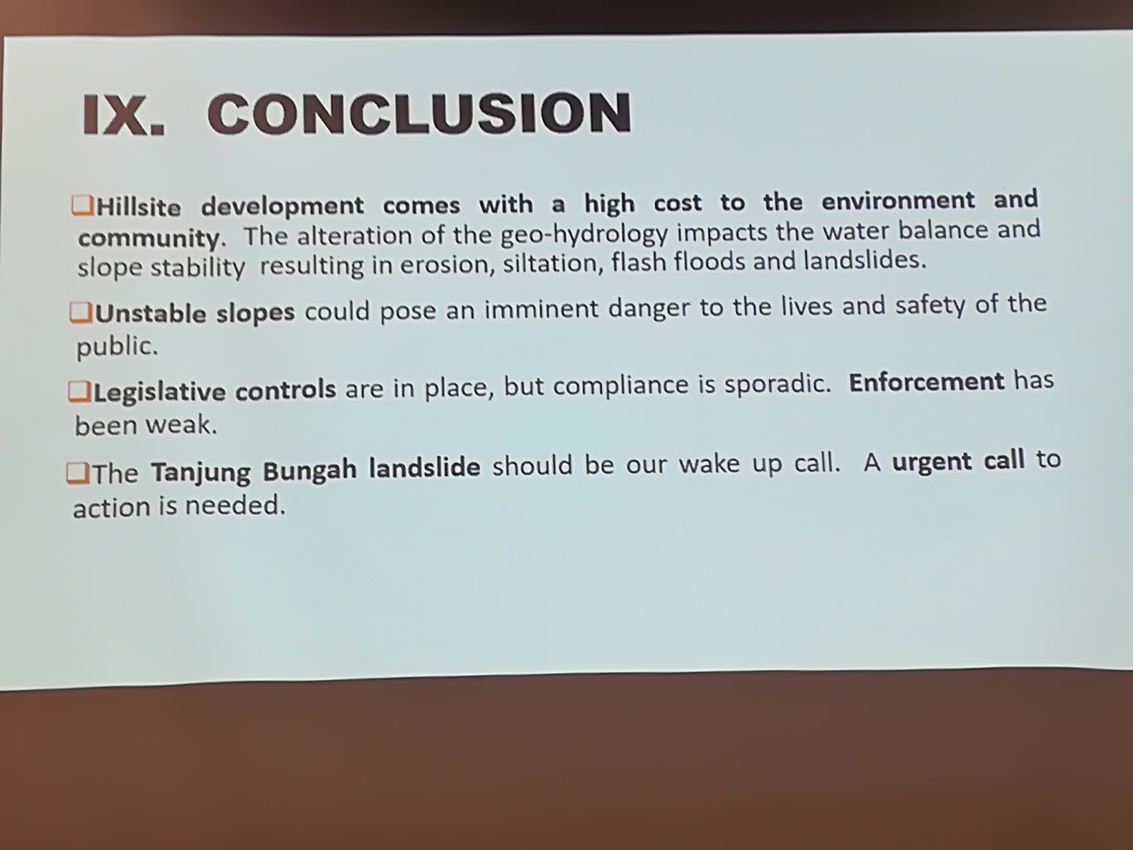
Why did MBPP approve the Tanjung Bungah development project? Read more at https://www.malaysiakini.com/letters/399357#qbRd534yu1JfC551....

https://youtu.be/kslhytLg-Wc Hills, landslides and floods: What to do?   The mega floods in Penang which followed the landslide...
 
Becoming bald: A view of the clearing work seen at Bukit Relau which was visible from the Penang Bridge in November last year. GEORGE..

Choong (in white) surveying the deforested hillslope next to Majestic Heights. PENANG MCA has raised concerns about the safety of the r...

Friday, January 26, 2018

Penang Landslide occured days after remedial works started

Cracks at Tanjung Bungah site began in June, Commissioner of Inquiry told

Expert panel: (From right) Yeo, Dr Gue and Prof Ramli arriving for the inquiry.
 
GEORGE TOWN: A temporary structure supporting a worksite slope in Tanjung Bungah developed cracks in mid-June, a Commissioner of Inquiry heard.

Soil Mechanic Sdn Bhd director Cheah Wing How, who was a sub-contractor of the project where a landslide killed 11 workers, said he was informed by a clerk to carry out remedial works as the granite wall had cracked.

Cheah said his team left after completing the granite works and soil-nailing works to enhance the stability of the temporary slope.

There was, however, no mention when they completed the works.

“When we returned, we found there were pile cap excavation works carried out near the slope.

“We believe there was soil movement that resulted in the cracks on the granite wall.

“We were carrying out remedial works and 11 days into the job, the landslide happened,” said Cheah, who has 20 years’ experience in the field.

Cheah was testifying on the first day of the public hearing into the landslide tragedy by the State Commission of Inquiry (SCI) at City Hall in Esplanade yesterday.

On Oct 21, last year, a landslide hit the affordable condominium project made up of two 49-storey towers with 980 units in total within the Permai Village township near the Tunku Abdul Rahman University College.

Among the 11 killed was site supervisor Yuan Kuok Wern, 27.

During the proceeding, the Penang Island City Council (MBPP) also presented eight drone videos that showed the slope and the surrounding area after the tragic incident.

SCI chairman Datuk Yeo Yong Poh said they planned to carry out a site visit tomorrow.

He also fixed the hearing to continue until Monday, followed by Feb 8 to Feb 11, March 24 to March 28 and April 18 to 25.

Other members of the commission are geotechnical expert Datuk Dr Gue See Sew and forensic geo-technical engineer from Universiti Teknologi Malaysia Prof Ramli Nazir.

The SCI was gazetted on Dec 21 last year to investigate the landslide after Yang di-Pertua Negri Tun Rahman Abbas gave his consent on Dec 6, 2017, for the appointment of the members of the commission and its terms of reference.

Meanwhile, Penang Citizens Awareness Chant Group (Chant) adviser Yan Lee said the entrance to the Teik Granite Quarry, which is located near the site where the landslide occurred, should be fenced up.

“Anyone can just walk into the site as the safety measure is not up to mark.

“We have voiced our concern to the Penang Island City Council, the Department of Environment as well as the Land and Mines Department,” he said yesterday.

By Chong Kah Yuan and Jo-Leen Wong The Star


Related Links:

Boulders slid down hill prior to disaster - Nation


Contractors in jitters over temporary slopes - Nation


Related posts:

Penang landslide tragedy, plea went unheeded, no one listened !


Behind BJ Cove houses at Lintang Bukit Jambul 1 is an IJM Trehaus Project.  Approximate Coordinates : 5°20'38.47"N,100°16'..

Tuesday, November 7, 2017

Penang bald Hillslopes a "time bomb"

Choong (in white) surveying the deforested hillslope next to Majestic Heights.

PENANG MCA has raised concerns about the safety of the residents in Tingkat Paya Terubong 4, right behind the Majestic Heights flats

Its Bukit Gelugor deputy secretary Marvyy Choong said the deforested hill behind the flats, just a stone’s throw away from Block 1, was a time bomb.

“There are 12 blocks of 23-storey flats in Majestic Heights.

“I understand that many residents have already moved out, leaving only a few more, and we’re worried for their safety.

“The surrounding hills are going bald due to ongoing earthwork and the 12 blocks may all collapse during a landslide,” he told a press conference at the flats yesterday.

He added that the hill clearing work was done by a housing project developer, which is also responsible for the paired road linking Bukit Kukus and Bukit Jambul.

Credits - Slides presented by Environmental, health and safety consultant Aziz Noor, and scientist Dr Kam Suan Pheng at the Penang Forum event on Oct 29, 2017


Aishah looking out her window to the hillslope which is just a stone’s throw from her unit

“We are not opposing the paired road project but we’re against high-rise projects in vulnerable areas that may endanger lives,” he said.

Choong said Jalan Paya Terubong was not safe as trees frequently fall during a downpour.

“It is also unsafe for heavy vehicles and they must be banned from using this road after the paired road is completed.”

Meanwhile, housewife Aishah Che Wan, 68, who is living at another apartment scheme near the same hill, said muddy water gushed down the hill on Saturday and Sunday.

“Some small stones damaged a few cars parked by the side of the road,” she said, adding that she now feared for the safety of her family.

“I hope that whoever is clearing the hill will take necessary safety measures to prevent any mishap,” she said. - Starmetro


Related posts:

Behind BJ Cove houses at Lintang Bukit Jambul 1 is an IJM Trehaus Project.  Approximate Coordinates : 5°20'38.47"N,100°16'


Becoming bald: A view of the clearing work seen at Bukit Relau which was visible from the Penang Bridge in November last year. GEORGE...
https://youtu.be/kslhytLg-Wc Hills, landslides and floods: What to do?   The mega floods in Penang which followed the landslide...
Seeking solutions: Penang Forum member and soil expert Dr Kam Suan Pheng giving her views during the dialogue session themed ‘Penang Fl
Council should not bow to development or political pressure, says city councilor, Khoo ‘Politicians should be ‘wakil rakyat’ and n...

Wet, wet woes: (Above) Bukit Jambul is flooded once again after an evening downpour. Firemen installing a pump to draw floodwater...
Put on hold: A view of the site for the development of four apartment buildings in Paya Terubong, Air Itam. GEORGE TOWN: Since the ...
GEORGE TOWN: Penang has tabled a higher deficit state Budget of RM740.5million for the next fiscal year of 2018. Chief Minister Lim Guan

Monday, November 6, 2017

Hills, landslides, floods and damaged houses: What to do?

https://youtu.be/kslhytLg-Wc

Hills, landslides and floods: What to do?


The mega floods in Penang which followed the landslide tragedy, flash floods in Kuala Lumpur and Petaling Jaya, and a shrinking water catchment area in Ulu Muda ... it’s time our leaders paid attention to the environment.


THE news has been full of the related issues of hill cutting, logging, landslides and floods. The environmental crisis is back in the public consciousness, and we should seize the moment to find solutions and act on them.

Penang has been the epicentre of this upsurge, for good reasons: the mega flash floods and landslides over the weekend and on Sept 15, and the Oct 21 hill slope collapse in Lembah Permai (Tanjung Bungah) which killed 11 employees at a construction site.

Saturday’s overwhelming floods in Penang, which paralysed the island in so many ways and affected lives, property and activities, was a megashock not only to people in the state but throughout the nation.

But it’s not just a Penang phenomenon.

On Oct 30, flash floods caused massive traffic jams in Kuala Lumpur and Petaling Jaya.

Federal Territories Minister Datuk Seri Tengku Adnan Tengku Mansor said the floods were caused not only by heavy rain but by developers of two projects that had blocked drainage.

A stop­work order will be issued if the developers do not take measures specified by City Hall.

Another threat is the logging of valuable water catchment areas.

The Ulu Muda forest in Kedah, which provides much of the water supply to Kedah, Penang and Perlis, is under such a threat as the originally designated Ulu Muda water catchment area has shrunk by 87% from 98,400ha in 1969 to 12,484ha in 2017.

The forest reserve was the most important water catchment area in the Northern Corridor Economic Region but timber production there was growing because Kedah depended on logging as a source of income, said Penang Water Supply Corporation CEO Datuk Jaseni Maidinsa ( The Star, Oct 27).

He suggested that the federal government compensate Kedah for gazetting and preserving Ulu Muda as a water catchment area, noting that the Muda Dam provided 80% of the daily raw water needs for Kedah.

Jaseni issued this stark warning: when logging affects the Muda Dam’s ability to store sufficient water, all three states would face a water crisis in the next dry season.

In Penang, the debate on the floods and the tragic landslide has continued non­stop and moved last week to the State Assembly.

The clearest explanation of the worsening flood situation that I have heard was the presentation by scientist Dr Kam Suan Pheng at the Penang Forum event on Oct 29.


A former Universiti Sains Malaysia academic who then worked in international agencies including the International Rice Research Institute, Dr Kam said there were seven main causes of floods in Penang:

  • > Increasingly heavy rainfall; 
  • > Expansion of impermeable surface area;
  • > Eroded soil and landslides increase the sediment load in surface runoffs;
  • > Debris that clogs up waterways; 
  • > Accumulation of surface flow downstream;
  • > Limited capacity to channel off discharge; and
  • > High tides slow down discharge to the sea.

She provided historical and current data to show that flash floods are happening more frequently and with more adverse effects, even with lower rainfall levels. With higher rainfall expected in future, the situation can be expected to significantly worsen.

Dr Kam focused on expansion of impermeable surface area (caused by ill­ planned development and replacing natural ground cover such as hills, fields and trees that act as a water ­absorbing sponge) and soil erosion and landslides (caused by cutting and development in hill areas) as two factors that need special attention.

She quoted Datuk Kam U Tee, the Penang Water Authority general manager (1973~­90), as having correctly explained the Penang floods of October 2008, as follows: the floods were caused by conversion of the Paya Terubong and Bayan Baru valleys into “concrete aprons that do not retain water. The water immediately flows into streams causing flash floods even with moderate rainfall. Because of hill­cutting activities, the flowing water causes erosion of the slopes which carries mud and silt into the river beds”. ( The Star, Oct 24, 2008).


Flood mitigation and flood prevention are two types of actions to tackle the flood problem, said Dr Kam.

Mitigation measures only tackle the symptoms, are costly and need public (state and federal) funds. These include structural measures (upgrading rivers, installing pumps) and non­structural measures (drainage masterplan; flood forecasting and warning systems; public education).


Flood prevention should be the priority as that would tackle the root causes, said Dr Kam, who proposed the following actions:
  • > Proper land-­use planning and development control;
  • > Environmental, drainage, transportation and social impact assessments should be made   regarding development plans, beyond individual development projects;
  • > Stringent protection of hill land and slopes;
  • > Stringent monitoring of development projects;
  • >More greening of urban spaces, including a system of parks; and 
  • >Protection of riverbanks. 


To take these measures, policymakers have to deploy a wide range of policy and legal instruments, and to adopt environmentally sensitive and ecologically friendly structural and non­structural solutions, concluded Dr Kam.


Another speaker, Datuk Agatha Foo, complemented Dr Kam nicely when she elaborated on the various laws, guidelines and plans that can be used to prevent the wrong kinds of development, to control and monitor approved developments and to strictly enforce the laws.


She also spoke on the loopholes and weaknesses of the laws and how to correct them.

Events of the past few weeks alone indicate that the number of environment ­related and human-made problems are bound to increase, probably many times, unless our leaders and policymakers give higher priority to the environment and to well­ planned development. The paradigm shift should start now, as the alarm bells have already rung.


Source: The Star Malaysia director@southcentre.org Martin Khor Martin Khor is executive director of the South Centre. The views expressed here are entirely his own.


Related posts:

Seeking solutions: Penang Forum member and soil expert Dr Kam Suan Pheng giving her views during the dialogue session themed ‘Penang Fl...
Becoming bald: A view of the clearing work seen at Bukit Relau which was visible from the Penang Bridge in November last year. GEORGE...
Behind BJ Cove houses at Lintang Bukit Jambul 1 is an IJM Trehaus Project.  Approximate Coordinates : 5°20'38.47"N,100°16'...
Council should not bow to development or political pressure, says city councilor, Khoo ‘Politicians should be ‘wakil rakyat’ and n...
Speaking out: Penang Forum members protesting outside the CAP office in George Town. Don’t just make it about worker safety issues ...
https://youtu.be/QB45Q2_mOG0 Suspicious activity: A photo taken from Penang social activist Anil Netto's blog showing an active  
(From left) Dr Kam will deliver a talk on ‘Understanding the Causes of Floods and Seeking Solutions. State assemblymen expressing
Three slammed over finwall tragedy GEORGE TOWN: An incompetent engineer, a irresponsible one and a neglectful senior civil servant hav...